Uttara Kannada Eco-tourism (Land of waterfalls):
Very little known is it has the largest forest cover in Karnataka and we decided to visit places around Sirsi instead of Karwar as it was March summer.
About Uttara Kannada: It is one of the least explored and has the largest forest cover in Karnataka. Probably the most beautiful place in Karnataka, with high density of tourist places/forest and less of human settlements. It is said that over 3/4th is covered with forest.
It is home for a number of waterfalls including Magod Falls, Sathodi Falls, Unchalli Falls, Vibhuthi Falls, Benne Hole Falls, Shivaganga Falls and many more unexplored/unnamed.
Tourist places:
Murudeshwar, Dandeli, Gokarna, Yana, Banavasi, Netrani Island, karwar, Devbag, Gerusoppa Valley, Magod Falls, Sathodi Falls, Unchalli Falls, Kodasalli Dam backwaters, Vibhuthi Falls, Benne Hole Falls, Kavala Caves, Sintheri Rocks, Sahasralinga, Shivaganga Falls, Jenukallu/Jenukal Gudda
 |
| Bhairaveshwara Shikhara, Yana |
Routes:
There are four routes to choose for a 1/2 day trips, you may need at least 1 week to completely explore Uttara Kannada.
Route1: Karwar, Devbag, Gokarna, Yana, Vibhuthi falls, Gerusoppa Valley, Murudeshwar, Netrani Island are on the Karwar side
Route2: Dandeli, Kavala Caves, Sintheri Rocks are on the Dandeli side
Route3: Sahasralinga, Shivaganga Falls, Banavasi, Kodasalli Dam backwaters, Sathodi Falls, Jenukallu/Jenukal Gudda, Magod Falls are on the Yellapur side
Route4: Unchalli Falls, Burude Jog comes under Siddapur
 |
| Route and distance from sirsi put up in hotel! |
Travelogue: (March-2011)
Camera Used: KODAK EASYSHARE Z1012 IS Digital Camera, Nokia 5800 Xpres, Sony DSC-W180
Places covered:
Day1-Fri(train): Bangalore(night) - Shimoga(morning)
Day2-Sat(SUV): Shimoga – Sirsi(Shimoga-sagara-siddapur-Sirsi 145km) - Sahasralinga - Sathodi Falls - Backwaters of Kodasalli Dam - Magod Falls - Jenukallu/Jenukal Gudda - Sirsi
Day3-Sun(SUV): Sirsi - Yana - VibhutiFalls - Shimoga
Day4-Mon(Bus): Shimoga(night) - Bangalore(morning)
Day1: We started our journey night from Bangalore in train and reached Shimoga in the early morning around 5am.
Day2: Met our friend at Shimoga and started our drive in his SUV from Shimoga towards Sirsi where we got ready after booking hotel room. We quickly got the route plans with the locals and hotel staff and decided to cover route 3(Yellapur side) on day 1 and route 1(Karwar side) on day 2.
We started towards sahasralinga and reached at around 11.30am. The place was said to have thousands of Shiva linga's carved on the stones around the river Shalmala, but we could spot only hundred's though few more must have vanished through the ages due to lack of maintenance. We had a good relaxed time at sahasralinga by playing in the waters in the hot summer sun.
 |
| River Shalmala |
 |
| sahasralinga |
Then later we started towards Sathodi falls near Kallaramarane Ghat 32 km from Yellapur and reached the parking at 1.30pm and started to trek through the forest cover. The trek is around 2km (20mins) which might be very difficult in rains as it is very slippery. There is a water stream all through the trek route. Not advised for old age people.
We reached the falls around 2pm and were quite amazed by its beauty. The falls is around 15 meters (49.2 feet) tall. You can actually play under the falls in summer when the water is low. The entire place around is roofed with thick forest.
 |
| Sathodi falls |
 |
| Rock formations around Sathodi falls |
 |
| Rock formations around Sathodi falls |
Playing in water for over an hour started to trek back to the restaurant near the parking place. Reached the restaurant at around 3.30pm. Remember you need to book the lunch before u start your trek towards the falls.
 |
| Restaurant at Sathodi Falls |
The stream then flows into the backwaters of the Kodasalli Dam, into the Kali River. Had a quite good lunch there and then came down the hill to see the impressively beautiful Kodasalli Backwaters also called as Shivapur valley.
 |
| Kodasalli Backwaters |
 |
| Kodasalli Backwaters |
 |
| Kodasalli Backwaters |
And at 4.30pm we started our journey towards Magod falls(where the river Bedti falls from a height of nearly 200m in two steps) and reached the falls at 6pm. Since it was summer there was no much water visible from the view point. The falls is actually very far from the view point. But the valley down the falls is gorgeous. Best time to visit Magod falls is after heavy monsoons where you can witness the power of the Mother Nature with the water flow.
 |
| Magod falls |
 |
| Magod falls - Upper part |
The last place for the day as we decided was Jenukallu Gudda (situated 17Km from Yellapur. The Bedti River from Magod falls cuts across the green hills), which is one of the least popular place but I would say it should be more beautiful than Agumbe for sunset point. We reached the view point at 6.15pm and were sitting up the hill to have a mesmerizing view of the valley down and the sun set behind the hills. After relaxing quite a time till the sun completely went behind the hills we started towards our hotel at Sirsi at 7pm and had dinner at the hotel.
 |
| Sunset at Jenukallu Gudda |
 |
| Sunset at Jenukallu Gudda |
 |
| Sunset at Jenukallu Gudda |
 |
| Sunset at Jenukallu Gudda |
 |
| Stairs to reach the Jenukallu Gudda view point |
Day3: The next morning there was quite confusion about choosing the places for day2 as there are lot of places to cover around, but we finally managed to decide upon Yana and surrounding places, as Yana was our prime choice for the whole trip plan. We started the day at 10am after having breakfast at the hotel and vacated the hotel rooms.
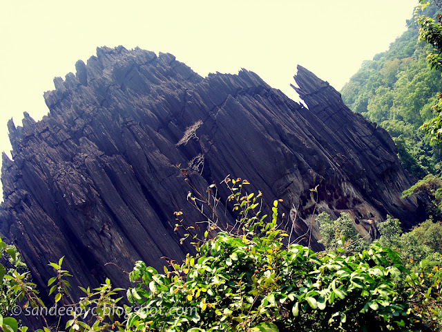
We reached Yana at 11.45am. The road was newly built and in excellent condition and to our surprise it stretched almost till Yana rocks. One has to trek only around 500mts to reach the rocks. For those who didn't catch what rock's I am citing here, a brief information about Yana, it is unusual rock formations, two massive rock outcrops known as the Bhairaveshwara Shikhara and the Mohini Shikhara composed of solid black, crystalline limestone, located in the Sahyadri mountain range of the Western Ghats, about 60km from Karwar, 40 km from Sirsi and 20 km from Kumta. Bhairaveshwara Shikhara is 120 metres (390 ft.) in height, while Mohini Shikhara is 90 m (300 ft.). The place is sacred for many as a pilgrimage Centre for the cave temple below the Bhairaveshwara Shikhara where a Swayambhu ("self-manifested") linga (Shiva linga) has been formed. One can explore the place around the rocks, which is very famous for trekking from Kumta.
 |
| Trek Route to Yana |
 |
| Bhairaveshwara Shikhara, Yana |
 |
| Mohini Shikhara, Yana |
We left Yana at 1.30 and drove towards Vibhuthi falls our next destination around 8km from Yana. As it is said that the falls is just down the hills, but we were losing our route since there are no road signs and no humans around to inquire about the route. Nevertheless the road was very bad but manageable with an SUV. Even though we had a local person from Sirsi to guide us, we still lost in the roads and finally managed to get a house in the mid of the forest and got the route back and finally found the place at around 2.30pm. We have to park our vehicle and trek through the forest for around 2km (around 20mins trek). The trek route is good till almost the falls and once you reach the falls you’ve to cross the river under the falls and reach the other side of the falls and then can play under the falls in water. The place is remote and is not advised to go in small groups. Vibhuthi falls is a cascading type of falls with over 6-8 falls one below the other. You can get a view of only 3-4 falls from the place. The remaining are lying below where you've to go down the rocks to get a view of the entire falls, though the main falls is on the top which is the biggest among them. We then reached the parking place at 4.45pm and had our lunch which we had brought parcel from the Sirsi hotel.
 |
| Trek route to Vibhuthi falls |
 |
| Vibhuthi falls |
We then left the place towards Shimoga. On the way near Shimoga halted to have coffee at Panchavati around 6.30pm and continued to towards and finally caught our bus from Shimoga to Bangalore back and reached Bangalore in the morning the 4th day. And have to go to office which was so disturbing though, with all the memories of life which lasts forever.


Comments
Post a Comment